Page 1 of 1
Border of Luxor Governorate
Posted: Wed Dec 11, 2013 9:21 am
by Brian Yare
Looking at various maps, it would appear to me that the New Valley Governorate starts at or about the edge of the cultivation on the West Bank at Luxor, so that many of the WB temples, and some housing that I would have expected to be in Luxor actually belong in NV. Am I reading this correctly, or is it just an error on the maps?
e.g.

If I am interpreting this correctly then the Foreign Office advice against non-essential travel to Sohag probably does not include Abydos.

Re: Border of Luxor Governorate
Posted: Wed Dec 11, 2013 11:08 am
by newcastle
According to all the information I can find, Abydos lies in the Sohag Governorate which would appear to mean it's still on the travel warning list....unless the Governorate borders have changed?
Re: Border of Luxor Governorate
Posted: Wed Dec 11, 2013 7:12 pm
by Brian Yare
newcastle wrote:According to all the information I can find, Abydos lies in the Sohag Governorate which would appear to mean it's still on the travel warning list....unless the Governorate borders have changed?
I know that Google earth is not the definitive resource for Egyptian political geography but it places Abydos in NVG. One would need to approach by the western desert road.
Kings Valley is also in NVG!
That is why I started this thread.
Re: Border of Luxor Governorate
Posted: Wed Dec 11, 2013 7:54 pm
by newcastle
Brian Yare wrote:
I know that Google earth is not the definitive resource for Egyptian political geography ....
Exactly. I think you'll find the the West Bank villages. Vof K etc. fall within the Luxor Governorate.....whatever Google Earth thinks !
Re: Border of Luxor Governorate
Posted: Wed Dec 11, 2013 9:44 pm
by A-Four
The Governorate of Luxor extends south to just past Essna, though I expect Google will not tell you that either.
Re: Border of Luxor Governorate
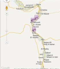
Posted: Thu Dec 12, 2013 7:58 am
by LivinginLuxor
Google Earth generally doesn't show borders within countries. The small images of maps of the governorates do give the impression that the New Valley does indeed cover Luxor however.
Here's a map from the Luxor governorate website, showing the boundaries of the governorate - the shaded area.
Re: Border of Luxor Governorate
Posted: Thu Dec 12, 2013 3:01 pm
by Brian Yare
LivinginLuxor wrote:Google Earth generally doesn't show borders within countries. The small images of maps of the governorates do give the impression that the New Valley does indeed cover Luxor however.
Here's a map from the Luxor governorate website, showing the boundaries of the governorate - the shaded area.
Your map is not a lot of use without a URL as the image is very low resolution.
But I went to the website and found nothing better.
Re: Border of Luxor Governorate
Posted: Fri Dec 13, 2013 7:57 am
by LivinginLuxor
Maybe, but I at least could easily read the names of towns, see the shaded area, and work out what was what! As that particular site is in Arabic, I didn't think that the URL would have helped.